


Unorg. Dist. 1, Beltrami County, Minnesota
About
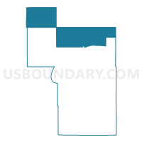
Outline

Summary
| Unique Area Identifier | 601138 |
| Name | Unorg. Dist. 1 |
| County | Beltrami County |
| State | Minnesota |
| Area (square miles) | 602.16 |
| Land Area (square miles) | 601.81 |
| Water Area (square miles) | 0.35 |
| % of Land Area | 99.94 |
| % of Water Area | 0.06 |
| Latitude of the Internal Point | 48.35068080 |
| Longtitude of the Internal Point | -95.04618850 |
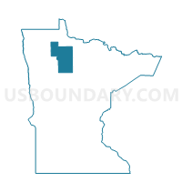
Maps

Graphs
Select a template below for downloading or customizing gragh for Unorg. Dist. 1, Beltrami County, Minnesota


Neighbors
Neighoring Voting District (by Name) Neighboring Voting District on the Map
- 2-C Unorg. Voting District, Lake of the Woods County, MN
- 3-D Forest Unorg. Voting District, Lake of the Woods County, MN
- America/Beltrami Island Forest Unorg. Voting District, Roseau County, MN
- Benville Twp. Voting District, Beltrami County, MN
- Golden Valley Twp. Voting District, Roseau County, MN
- Linsell Twp. Voting District, Marshall County, MN
- Little Rock Voting District, Beltrami County, MN
- Minnie Twp. Voting District, Beltrami County, MN
- Ponemah Prec., Beltrami County, MN
- Reine Twp. Voting District, Roseau County, MN
- Spruce Grove Twp. Voting District, Beltrami County, MN
- Steenerson Twp. Voting District, Beltrami County, MN
- Valley Twp. Voting District, Marshall County, MN
- Veldt Twp. Voting District, Marshall County, MN
- Waskish Twp. Voting District, Beltrami County, MN
- West Koochiching Voting District, Koochiching County, MN
Top 10 Neighboring County Subdivision (by Population) Neighboring County Subdivision on the Map
- Northwest Koochiching UT, Koochiching County, MN (463)
- Southeast Roseau UT, Roseau County, MN (231)
- Golden Valley township, Roseau County, MN (189)
- Valley township, Marshall County, MN (149)
- Waskish township, Beltrami County, MN (118)
- Reine township, Roseau County, MN (94)
- Benville township, Beltrami County, MN (86)
- Spruce Grove township, Beltrami County, MN (55)
- North Beltrami UT, Beltrami County, MN (34)
- Veldt township, Marshall County, MN (30)
Top 10 Neighboring Unified School District (by Population) Neighboring Unified School District on the Map
- Roseau Public School District, MN (6,728)
- Red Lake Public School District, MN (5,890)
- Lake of the Woods School District, MN (3,673)
- South Koochiching School District, MN (1,317)
- Grygla Public School District, MN (1,024)
- Kelliher Public School District, MN (1,022)
Top 10 Neighboring State Legislative District Lower Chamber (by Population) Neighboring State Legislative District Lower Chamber on the Map
- State House District 2B, MN (39,744)
- State House District 3A, MN (35,316)
- State House District 1A, MN (35,146)
Top 10 Neighboring State Legislative District Upper Chamber (by Population) Neighboring State Legislative District Upper Chamber on the Map
- State Senate District 2, MN (76,807)
- State Senate District 3, MN (73,721)
- State Senate District 1, MN (71,334)
Top 10 Neighboring 111th Congressional District (by Population) Neighboring 111th Congressional District on the Map
Top 10 Neighboring Census Tract (by Population) Neighboring Census Tract on the Map
- Census Tract 9400.01, Beltrami County, MN (5,885)
- Census Tract 9704, Roseau County, MN (3,755)
- Census Tract 7905, Koochiching County, MN (2,419)
- Census Tract 4604, Lake of the Woods County, MN (2,351)
- Census Tract 801, Marshall County, MN (2,325)
- Census Tract 4505, Beltrami County, MN (1,715)
- Census Tract 4603, Lake of the Woods County, MN (1,694)
Top 10 Neighboring 5-Digit ZIP Code Tabulation Area (by Population) Neighboring 5-Digit ZIP Code Tabulation Area on the Map
- 56751, MN (5,575)
- 56623, MN (2,749)
- 56727, MN (769)
- 56761, MN (488)
- 56627, MN (309)
- 56724, MN (159)
- 56685, MN (117)